Versatile software for merging 2D maps
Merge multispectral images and any other aerial images into an orthomosaic or create maps on the fly
UgCS Mapper is a lightweight and affordable drone image and video processing software developed by SPH Engineering to create 2D maps and elevation models.
Main benefits

Work offline in the field
UgCS Mapper is capable of operating exclusively offline, allowing you to quickly merge the map and validate the quality and density of the survey data before leaving the survey area.

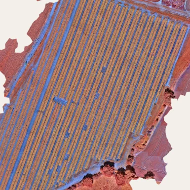
Merge multispectral points RGN JPEG
Upload 3-channel multispectral field JPEG RGN images into UgCS Mapper for merging and generating NDVI indices to assess crop health

Sewing on the fly
When predefined map sources are unavailable or outdated, it creates updated maps and elevation data on the fly. They are accurate enough to plan safe missions and guide first response teams.
How it works
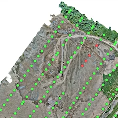
UgCS Mapper is extremely easy to use. Perform processing and create a map and elevation in just three clicks.

Image/video capture
Georeferenced JPEG (standard for DJI cameras) or video stream with UgCS ENTERPRISE
Processing with UgCS Mapper
Create Geotiff map and elevation

Use maps
Export for use with UgCS or other GIS software
How to create an orthophoto map from images acquired during automatic photogrammetric survey with UgCS
How to process multispectral images from MicaSense RedEdge cameras for crop health analysis
Industries
With UgCS Mapper, photogrammetric mapping can be done virtually anywhere and more affordably than ever before!
Survey and mapping
agriculture
Mining and quarrying
Mining and quarrying
Search and rescue
Construction
Features
Generation of orthophotos
Union of orthophotos from georeferenced JPG images.
Multispectral cameras
Merge 3-channel multispectral JPEG RGN images to generate NDVI indices. Compatible with Micasense RedEdge-M, RedEdge-MX
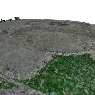
DSM data/elevation
Generates DSM/elevation data from georeferenced JPG images
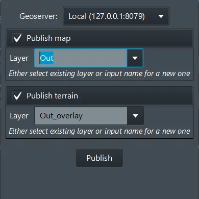
Integration
A new map one click away and DSM export from UgCS Mapper into UgCS
Prices
As a stand-alone software, UgCS Mapper performs mapping from drone images. Choose the license model that suits you best!


*For Perpetual
Annual support and update package 99 €/year starting from the 2nd year after purchase All prices without VAT
Supported operating system
The desktop-based image/video joining software UgCS Mapper can be run on:

Win

macOS

Linux (on request)
Customers in more than 150 countries use SPH Engineering solutions for drone mission planning, flight control and data management on a daily basis.
Do you still have any questions?
Send us a message and we will get back to you!
Call Us Now
for a free consultation on Hardware,
Software, and ENAC.
Book Now
your free phone consultation with our Experts.