Software
Showing 13–23 of 23 results
Discover our range of DJI drone software designed to optimize operations in various professional fields. We offer advanced solutions for mission planning, data processing, and fleet management, improving the efficiency and accuracy of your aerial activities.
Main features:
- Advanced mission planning: Create detailed flight paths with custom waypoints and specific actions for each mission phase.
- Efficient data processing: Quickly transform collected information into maps, 3D models and analytical reports.
- Integration with DJI hardware: Full compatibility with DJI drones, ensuring a seamless workflow.
Main applications:
- Topographic Surveys: Generates accurate maps for urban planning, civil engineering and agriculture.
- Industrial inspections: Monitors critical infrastructure such as power lines, pipelines and industrial facilities.
- Emergency management: Coordinates rescue operations and disaster response with real-time information.
Explore our selection of DJI drone software and enhance your operations with state-of-the-art technology tools, ensuring efficiency and accuracy in every mission.
- DJI FlightHub 2, Software
DJI FlightHub 2 Addon Storage 500 Gb
0 out of 5(0)Storage space upgrade package
DJI Flighthub 2 offers business users free 5 GB storage space, which can be used to store images, videos, flight paths, models, etc. You can purchase this package to increase the storage capacity.
SKU: DJF204659,00 € TAX Included - DJI FlightHub 2, Software
DJI FlightHub 2 Pro 1 Month
0 out of 5(0)Free device bindings and quotas
Livestream: additional 2000 minutes for each connected drone, plus 20000 minutes for each connected Dock.
Real-time mapping: additional 3000 mapping images for each connected drone.
Cloud storage: additional 200 GB storage space for each connected Dock.SKU: DJF201119,00 € TAX Included - DJI FlightHub 2, Software
DJI FlightHub 2 Pro 12 Months
0 out of 5(0)Free device bindings and quotas
Livestream: additional 2000 minutes for each connected drone, plus 20000 minutes for each connected Dock.
Real-time mapping: additional 3000 mapping images for each connected drone.
Cloud storage: additional 200 GB storage space for each connected Dock.SKU: DJF2021.209,00 € TAX Included - Georadar, Georadar & Magnetometer Combo, UgCS - SPH
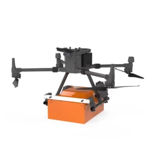
Georadar Drone - Zond Aero 1000 NG GPR
0 out of 5(0)The Zond Aero 1000 is an ultralight, single-unit ground penetrating radar (GPR) system specially designed for portable solutions. Compatible with DJI Matrice 300 and 350 drones, this georadar offers advanced performance for geophysical and archaeological survey applications.
SKU: n/aFrom 24.399,00 € TAX IncludedThis product has multiple variants. The options may be chosen on the product page - Georadar, Georadar & Magnetometer Combo, UgCS - SPH
Georadar Drone - Zond Aero 500 NG
0 out of 5(0)The Zond Aero 500 is an ultralight, single-unit ground penetrating radar (GPR) system specially designed for portable solutions. Compatible with DJI Matrice 300 and 350 drones, this georadar offers advanced performance for geophysical and archaeological survey applications.
SKU: n/aFrom 21.959,00 € TAX IncludedThis product has multiple variants. The options may be chosen on the product page - UgCS - SPH
UgCS
0 out of 5(0)UgCS is advanced software for drone mission planning and control. It supports photogrammetry, LiDAR and aerial scanning, optimizing professional operations. Compatible with various payloads, it offers an intuitive interface for automated missions.
SKU: n/aFrom 890,00 € TAX IncludedThis product has multiple variants. The options may be chosen on the product page
Showing 13–23 of 23 results


